First Responder Support Tools 4.2.1
Paid Version
Publisher Description
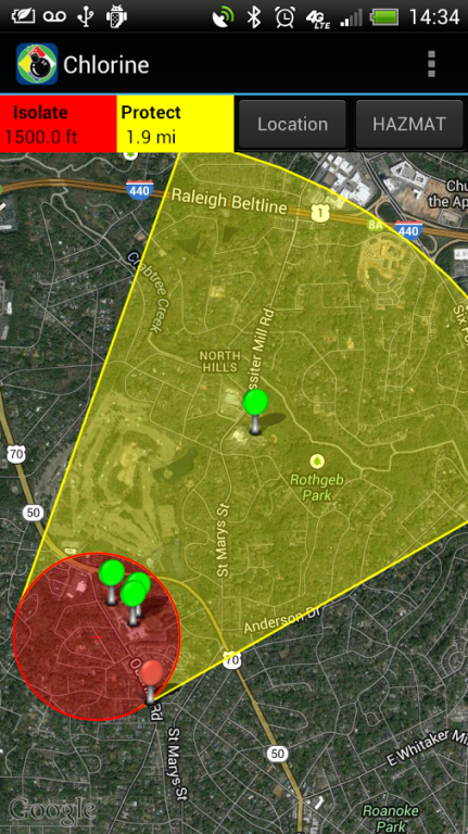
FiRST provides police, firefighters, security, and emergency management personnel easy access to map-based improvised explosive device (IED) standoff distances and hazmat spill evacuation areas. The IED standoff data is based on the 2016 Emergency Response Guide (ERG) and FEMA 426, Reference Manual to Mitigate Potential Terrorist Attacks Against Buildings. Users can also define custom IED types and standoff. Hazmat evacuation and reference data is based on the 2016 ERG.
Features of the software include:
- Display IED Mandatory Evacuation and Shelter-in-Place Zones for 8 pre-defined bomb sizes and user defined custom IED types
- Display Isolation Zones and down-wind Protection Zones for over 3,000 chemicals
- Display distance to glass breakage, injury, and structural damage based on bomb size
- Information displayed on Google Maps, with similar functionality to zoom, search by address, current location, and map/satellite/hybrid views
- Automatically retrieve current weather from Weatherbug (www.weather.weatherbug.com) or forecast weather from the National Weather Service (US only) or Meteorologisk Institutt (Worldwide); weather can also be user input or input using the phone’s compass functionality
- Results shown geographically as well as text based
- Search and display predefined points of interest (schools, nurseries, hospitals, police/fire stations, and government facilities) from Google Search services to identify key facilities within the incident area
- Run roadblock analysis service that identifies within seconds the optimal location of roadblocks to isolate the incident area
- Place and label points on the map to identify key locations
- One-button summary of results (text, map image, map data shape and kml file attachments) in an email to disseminate to other responding personnel
- Includes reference material from the 2016 ERG and important chemical contacts for quick calling
- Store map images (including legends) for reference when connectivity prevents access to network maps
For more information, go to http://www.firstsupporttools.com
About First Responder Support Tools
First Responder Support Tools is a paid app for Android published in the Reference Tools list of apps, part of Education.
The company that develops First Responder Support Tools is ARA Developer. The latest version released by its developer is 4.2.1. This app was rated by 1 users of our site and has an average rating of 5.0.
To install First Responder Support Tools on your Android device, just click the green Continue To App button above to start the installation process. The app is listed on our website since 2017-11-07 and was downloaded 181 times. We have already checked if the download link is safe, however for your own protection we recommend that you scan the downloaded app with your antivirus. Your antivirus may detect the First Responder Support Tools as malware as malware if the download link to com.ara.android.first is broken.
How to install First Responder Support Tools on your Android device:
- Click on the Continue To App button on our website. This will redirect you to Google Play.
- Once the First Responder Support Tools is shown in the Google Play listing of your Android device, you can start its download and installation. Tap on the Install button located below the search bar and to the right of the app icon.
- A pop-up window with the permissions required by First Responder Support Tools will be shown. Click on Accept to continue the process.
- First Responder Support Tools will be downloaded onto your device, displaying a progress. Once the download completes, the installation will start and you'll get a notification after the installation is finished.
